Monitoring and Imaging Vessels in Optix with Maxar Satellites
GA-CCRi‘s Optix platform provides easy access to low latency, high volume geospatial data and analytics at scale. We are continually striving to improve the global situational awareness of our customers by adding new capabilities and data modalities to the Optix platform. Many missions our customers conduct depend on timely access to new data, which requires tasking a new collection from an airborne or space asset.
To address this need, GA-CCRi is partnering with Maxar to leverage their satellite and imaging capabilities. Maxar employs a fleet of earth observation (EO) satellites that can take incredibly high-resolution images anywhere on the globe. With over 60 years of experience, Maxar is a leading force in the satellite, communications, and earth observation industry.
Typically, data (AIS) is used to locate vessels in the ocean. AIS is largely a safety feature that allows vessels to “see” other vessels around them, assist in navigation, and promote the security of the area. Vessels transmit information including their identity, position, course, and speed. Through our AIS feed — provided by Spire, the industry leader in global, real time AIS data—we can see in real-time what vessels around the globe are doing.
However, while most commercial vessels are legally required to continually transmit AIS, it can be voluntarily disabled or edited. It is not uncommon for vessels to turn their AIS off when engaging in clandestine behavior. For example, vessels engaging in illegal fishing, illegally exporting or importing products or attempting to avoid sanctions may periodically “go dark” and turn off or spoof their AIS transmission. Without a physical presence in the area, it is difficult, if not impossible, to determine where dark vessels are or what they are doing.
It is critical that our customers can continually monitor vessels— especially those who voluntarily turn off their AIS. In such situations, satellite imagery can be used to locate and monitor such vessels. By combining GA-CCRi’s experience with Maxar’s Crow’s Nest Maritime Monitoring and Security (MMS) capabilities, an optical and radar imagery tipping and cueing solution, we can leverage satellite imagery to keep track of locations and identify vessels engaging in illegal operations.
Catching Illegal Fishing
One common method of illegal fishing is the use of AIS beacons on fishing lines and nets. Many countries ban attaching AIS beacons to entities that are not boats or navigational buoys because it makes navigation difficult and dangerous. AIS feeds do not differentiate between obstacles like boats and nets bobbling in the water, making safe passage difficult. AIS transmission can also be lost if too many vessels are transmitting at once – which becomes increasingly likely as nets easily outnumber the number of fishing boats in an area. Further, bad actors often leave their AIS tagged nets in areas where they are not allowed to legally fish. This allows them to leave and return to collect their haul later without being caught.
Using AIS, we can identify areas where AIS-tagged fishing is taking place because the signature patterns of large-scale net fishing are easy to identify with a bird’s eye view. We tasked Maxar’s EO satellites, within Crow’s Nest MMS, to image an area in the East China Sea with such activity, and caught two vessels, seen below. The original pictures are quite cloudy; in fact, cloud coverage is incredibly common over the ocean, with various studies estimating that clouds are present between 70% and 90% of the time [1,2]. However, Crow’s Nest can still automatically detect vessels through the coverage, despite being difficult to see with the naked eye. These images can be enhanced to see what is going on under the clouds.
We can cross-reference the times and locations these ships were imaged at against our AIS feed to identify determine the broader context of their activities. First, we will focus on Vessel A. In the video below, the location of Vessel A is represented by a blue circle, and the time and location of the satellite picture by a red circle. We can see that a fishing vessel transmitting AIS passes through that exact location at the time the picture was taken. This vessel then rounds the corner and begins picking up AIS-tagged fishing nets, in white, which bob in the water before being taken aboard.

While this vessel is using AIS tagged nets for fishing, an activity that is illegal in many countries, it is continually transmitting AIS as it should.
Vessel B is a different story. This vessel is fishing in the same area as Vessel A – only ten kilometers away – and its size and shape are that of a fishing vessel. However, by cross-examining the AIS data, it is clear there is no vessel transmitting AIS at that time and location, or any around that could correspond to it. Instead, right after the picture is taken, one net appears in the water just south of that location, then many more begin to be dropped in the characteristic loop pattern, bobbing in and out of the water. There is no visible AIS signature of anything but nets. Thus, Vessel B was likely captured by the satellite on its way south as it got into position to drop the fishing nets.

Vessel B is likely a true dark ship that is fishing with no AIS transmission. Proof of this vessel could not have been seen with traditional AIS tracking alone.
Confirming Vessel Identity
Using satellites to monitor the ocean is not a simple task. In our fishing example, we focused on a known location that we identified using patterns of AIS. However, most vessels in the ocean are constantly moving. To take a picture of a moving vessel, we must make a precise prediction of the vessel’s location and coordinate it with the timing of the satellite passing overhead. Fortunately, GA-CCRi's vessel forecasting service is built upon the culmination of our many years of experience, our deep mined vessel routes database, and our advanced prediction algorithms. This allows us to forecast where vessels will be accurately enough to tip the satellites to hyper-specific locations, at times over eight hours in advance.
With these abilities, we can confirm the identities and locations of actively moving vessels that may be engaging in illegal activity. For example, a variety of complex methods are used to move illegal products in and out of sanctioned countries. While it seems simple enough to turn off a vessel’s AIS to avoid detection, some vessels take this a step further. Instead of just going dark, the vessels will spoof their unique identifier and location. So, while a tanker may be heading towards a sanctioned country to export oil, any AIS feed will show the vessel in a completely different area of the world, moving toward a permitted port. Therefore, simply seeing a vessel’s unique AIS signature in the right location is not always proof of proper behavior. In these circumstances, satellite imagery can be used to confirm that a specific vessel is at the location that it claims to be.
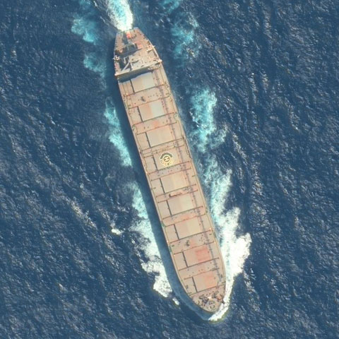
Below, we have a satellite image of a cargo ship whose location we predicted seven hours in advance to take this picture. Necessary lead times are typically much shorter for Maxar’s satellites, but with our forecasting service we can extend this time much farther into the future. Though the satellites were over 500km above the earth, the 30cm image is detailed enough to see the rust on the surface of the ship and other unique features that can be used to confirm its identity.
As we have shown, traditional AIS data can be combined with EO satellites to image, identify, and determine when vessels are engaging in illegal and unregulated actions. Imaging expands our confidence that vessels are who they say they are, where they say they’re at. We are excited to continue our partnership with Maxar and expand the solutions we can offer to our customers in this area.
- M. D. King, S. Platnick, W. P. Menzel, S. A. Ackerman and P. A. Hubanks, "Spatial and Temporal Distribution of Clouds Observed by MODIS Onboard the Terra and Aqua Satellites," in IEEE Transactions on Geoscience and Remote Sensing, vol. 51, no. 7, pp. 3826-3852, July 2013, doi: 10.1109/TGRS.2012.2227333.
- S. Warren, R. Eastman, C.J. Hahn, “CLOUDS AND FOG | Climatology” in the Encyclopedia of Atmospheric Sciences, pp 161-169, doi: 10.1016/B978-0-12-382225-3.00113-4.